Archaeology & Ancient Sites
Culbokie has been visited or occupied by man for several thousand years so was obviously thought to be a good place to live.
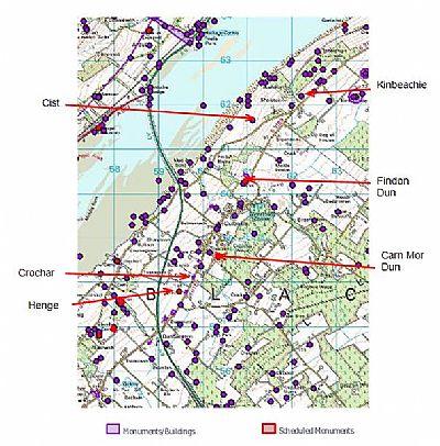
The map below reproduced from the Highland Historic Environment Record (HER) web site gives a clear indication of the range of archaeological sites around Culbokie.
The Highland HER web site provides a search facility at https://her.highland.gov.uk/monuments/search On this page to access records relevant to this area pull down the Parish menu and select Urquhart and Logie Wester and click on Search. This will produce 26 pages of 10 records per page of relevant records. WARNING. A significant number of the records refer to buildings that appeared on the 1st edition of the OS 6-inch map (Ross-shire and Cromartyshire 1880, sheet lxxvii), but are not shown on the current edition of the OS 1:10000 map (1977). We have ignored these. Also many of the records state that there is "No summary available" thus not being very helpful. There are a few duplications. We have attempted to apply links to the relevant records from within our pages listed below. A full list might be provided when this update has been completed.
Index
- The archaeology of the area
- Càrn Mòr Dùn AKA Culbokie Castle
- Findon Dun - the Canmore record erroneously refers to this as "Findon Cottage", the correct location is Findon Mills.
- Teanagairn Henge
- Roundhouses
- Findon Cist & Urn
- Crochar - the Highland Historic Environment Record for "Crochar" does not refer to 'our' Crochar.
- Ferintosh Distillery and chambered cairn.
- The Fisher Folk of Findon
- Kinbeachie Castle & Farm (see note below map) Page updated November 2024
- Castle Craig
- Metal detecting
Two archaeological sites not identified below are the Drummondreach Dun at map reference NH582575 (whilst there have a look at the Preaching Site) and the Chambered Cairn at the Old Ferintosh Distillery site at map reference NH577568
Highland Historic Environment Record for the Drummondreach Dun.
Highland Historic Environmental Record for Drummondreach hut circle, including photographs.

Kinbeachie: On the map above the label "Kinbeachie" points to the location at the farm where excavations took place in 2003 by J. Wordsworth.
Kinbeachie Castle: This is located at the extreme right hand edge of the map above just below the red arrow.
HER records of artifacts.
https://her.highland.gov.uk/Monument/MHG9024 Axe mould - Ferintosh
https://her.highland.gov.uk/Monument/MHG9006 Flat axe
https://her.highland.gov.uk/Monument/MHG61449 Bronze ingot - Balloan
https://her.highland.gov.uk/Monument/MHG8229 Carved stone ball Greenleonachs
https://her.highland.gov.uk/Monument/MHG51719 Cup marked stone, poor condition on Findon foreshore

